linkedin
Nexys logo
play Meet Nexys - A Modular Mapping & Surveying Ecosystem
Nexys Autonomous
Nexys Configurable

Nexys

Brand: Exyn Technologies

  • 4.4

  • 6 Ratings

Nexys is a modular 3D mapping solution that uses proprietary autonomy algorithms and SLAM-based LiDAR scanning to deliver survey-grade results in complex, GPS-denied environments and can be configured for various applications like handheld backpack, and aerial robot use.

See More

Have you used Nexys before?

Share your insights for better experience

Add a Review

Price Available on Request

Questions about pricing or customization? We’re here to help, just a click away.

100% Genuine
Products
Best Price
Guaranteed
Safe & Secure
Payment
  • Description

  • Pricing

  • Features

  • Specification

  • Review

  • Compare

  • FAQ

Nexys Software Overview

What is Nexys?

Nexys is a modular 3D mapping photogrammetry software designed to enhance efficiency and safety in complex, challenging, or hazardous environments. It uses proprietary autonomy algorithms and SLAM-based LiDAR scanning technology to deliver survey-grade results without needing a pilot. Nexys can switch between multiple configurations such as handheld, backpack, aerial robot, terrestrial robot, vehicle, and custom setups.

It offers real-time visualization of captured data in the field, ensuring accuracy and completeness before leaving the site. Built to IP67 standards, it provides robust protection against water and solid ingress. The integrated ExynView software enables fast on-premise processing, creating clean, georeferenced point clouds. Additionally, it features real-time 360º colorization with hemispherical cameras and includes a ruggedized Dell Latitude tablet for easy mission planning and monitoring.

Why Choose Nexys Software?

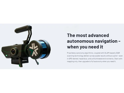
  • Advanced Autonomous Navigation: Uses proprietary algorithms and SLAM-based LiDAR for survey-grade results without a pilot.
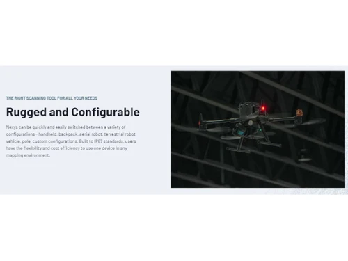
  • Rugged and Configurable: Quickly switches between handheld, backpack, aerial, terrestrial, vehicle, pole, and custom setups and is built to IP67 standards for flexible use in any mapping environment.
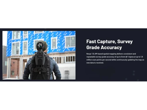
  • Fast Capture, Survey-Grade Accuracy: Achieves consistent 5mm accuracy at 1 sigma with 1.9 million scan points per second.
  • Real-Time Field Visualization: Captures and processes data in the field for real-time visualization.
  • Onboard Intelligence and ExynView Software: Controls capture and post-processing for fast on-premise results.
  • IP67 Standards: Offers highest protection against water and solid ingress for diverse environments.
  • Real-Time 360º Colorization: Hemispherical cameras cover 100% of the LIDAR view for fully colorized point clouds.
  • Ruggedized Tablet Integration: Includes a ruggedized Dell Latitude tablet for mission planning and real-time monitoring.

Benefits of Nexys Platform

  • Efficiency: Reduces the time needed to capture data while increasing safety in challenging environments.
  • Versatility: One device can be used in multiple configurations, reducing the need for multiple devices and saving costs.
  • Accuracy: Provides survey-grade accuracy with high scan points per second, ensuring precise and reliable data.
  • Real-Time Feedback: Allows for real-time visualization and verification of scans in the field, reducing the need for repeat visits.
  • Durability: Built to withstand harsh conditions, ensuring reliable performance in demanding environments.
  • Cost-Effective: Offers a cost-efficient solution by combining multiple functionalities into a single, versatile device.
  • Advanced Analysis: Integrates with AI tools for enhanced data analysis and defect detection, providing deeper insights.

Pricing of Nexys

Nexys price details are available on request at techjockey.com.

The pricing model is based on different parameters, including extra features, deployment type, and the total number of users. For further queries related to the product, you can contact our product team and learn more about the pricing and offers.

Read more

Exyn Technologies Company Details

Founded Year:  2014

Exyn Technologies is a developer of autonomous aerial robot systems.

Director/Founders Nader Elm, Vijay Kumar
Company Size 1-100 Employees

Nexys Pricing & Plans

Looking for The Right Pricing?

Share your requirements and get a plan built around your business.

  • Define your business needs
  • Get customised pricing
  • Choose features that fit your workflow

Price Available on Request

Get personalised Nexys pricing that fits your needs. Our team will connect with you.

Nexys Features

  • icon_check 3D Modeling
    It creates detailed 3D models from photos, accurately capturing both geometry and textures.
  • icon_check 3D Imagery
    It visualizes 3D models and scenes from photogrammetry data, providing a clear view of spatial information.
  • icon_check Image Exporting
    Users export processed images from It for analysis or integration into other software.
  • icon_check Geocoding
    Nexys assigns geographic coordinates to data, enhancing spatial context and location-based analysis.
  • icon_check Map Sharing
    Users share maps and spatial data created with Nexys, fostering collaboration among project stakeholders.
  • icon_check Site Progress Tracking
    It monitors site development over time using updated 3D models and imagery, aiding in project management.
  • icon_check Photogrammetry
    Creates detailed 3D models and maps from drone-captured images.
Nexys Demo Video play icon

Get Nexys Demo

Watch the demo video to explore key features, real workflows, and how the software fits your business needs.

Understand
Key Features
Personal
Demo Insights
Interactive
Demo Support

Nexys Specification

Supported Platforms
Ubuntu Ubuntu Windows Windows MacOS MacOS Linux Linux
Devices
Desktop Desktop
Deployment
Web-Based Web-Based
Suitable For
All Industries
Business Specific
All Businesses
Business Size
Small Business Medium Business Enterprises
Customer Support
Email Communities
Language
English
Training Resources
Videos
AI Features
AI Integrated

Explore the Best Alternative Solutions Similar to Your Business Size and Needs

Nexys Review

4.4

Out of 5

img

Overall Rating

Based on
6 Verified Ratings

Rating Breakdown

  • Features 4.5
  • Value for Money 4.5
  • Ease of Use 4.4
  • Customer Support 4.2

93% Recommend this Product

Add Review

Be the First to Review

This product has no reviews yet. Be the first to leave your feedback.

Add Review

Compare Nexys With other Photogrammetry Software

Products
Ratings
Pricing
Device Supported
Deployment
Supported Platforms
  • img

    Nexys

  • 4.4

  • Price On Request

  • Desktop

    Mobile

  • Web based

    On Premises

  • Windows

    Mac OS

  • img

    Autodesk ReCap

  • 4.2

  • Price On Request

  • Desktop

    Mobile

  • Web based

    On Premises

  • Windows

    Mac OS

  • img

    Agisoft Metashape

  • 4.3

  • Price On Request

  • Desktop

    Mobile

  • Web based

    On Premises

  • Windows

    Mac OS

  • img

    ImageStation

  • 4.1

  • Price On Request

  • Desktop

    Mobile

  • Web based

    On Premises

  • Windows

    Mac OS

  • img

    PhotoModeler

  • 4.1

  • Price On Request

  • Desktop

    Mobile

  • Web based

    On Premises

  • Windows

    Mac OS

  • img

    PIX4Dmapper

  • 4.1

  • Price On Request

  • Desktop

    Mobile

  • Web based

    On Premises

  • Windows

    Mac OS

  • img

    Mapware

  • 4.1

  • Price On Request

  • Desktop

    Mobile

  • Web based

    On Premises

  • Windows

    Mac OS

(0) Product(s) selected

Which operating system does Nexys software support?

Nexys software supports Ubuntu, Windows, MacOS, and Linux.

How much does Nexys software cost?

Pricing information for Nexys software varies and typically requires requesting on techjockey.com.

Is there a Nexys software app?

Nexys software primarily runs on desktop platforms; there isn't a dedicated mobile app available.

Does Nexys offer a free trial?

No, Nexys software does not offer a free trial period.

How does Nexys software work?

Nexys software processes and visualizes spatial data from various configurations (handheld, aerial, etc.) in real-time, providing accurate, georeferenced 3D maps and models.

Who are the potential users of Nexys software?

Potential users of Nexys software include surveyors, construction managers, mining engineers, industrial inspectors, environmental researchers, and professionals in geospatial analysis and mapping.

Is there a free demo for Nexys software?

Yes, Nexys software usually provides a free demo or trial version for users to explore its functionalities before purchasing.

Does Nexys software require internet connectivity to operate?

Nexys software typically does not require constant internet connectivity for its core functionalities. However, internet access may be needed for updates or certain features.

Can Nexys software handle aerial photogrammetry projects?

Yes, Nexys software is capable of processing aerial photographs to create 3D models, making it suitable for aerial photogrammetry projects.

20,000+ Software Listed

Best Price Guranteed

Free Expert Consultation

2M+ Happy Customers

Terms and Condtions

close

Users with registered businesses can purchase goods from merchants on the platform to satisfy their business needs. Users are not permitted to utilize any products acquired through the platform for resale, advertising, business, or further distribution.

For each purchase made, users will receive a Tax Invoice (or 'GST invoice') that includes specific details such as:

  • the GSTIN of the user associated with their registered business, and

  • the specified Entity Name for their business.

It should be noted that not all products are eligible for GST Invoice. Only the products displayed by participating sellers with the 'GST-based Invoice Available' callout on the product description page would qualify.

Certain goods and services are not eligible to get a GST Invoice, including items with VAS, i.e., Value Added Services (e.g., Total Mobile Protection/Assured Buyback) and those involving an exchange offer at the time of purchase.

Users must ensure the accuracy of the GSTIN, and business entity name provided for the GST Invoice. Requests for corrections into GST Invoice would not be accommodated by Techjockey.com or any Seller, and any issues arising from user-provided information are the sole responsibility of users.

Techjockey.com is not liable for the GST Invoice or any associated input tax credit. To efficiently claim an input tax credit, users should select the registered place of business address as per the GST authority's data and follow the provisions of the GST Act and rules.

To claim an input tax credit, the delivery and billing addresses must match. Furthermore, input tax credits will not be granted if the delivery address and GSTIN on the invoice are from different states. In case of incorrect GST details provided during the order placement, the order will be canceled automatically.