USA
USA UAE
UAESmall Business
Designed for startups and growing businesses


See More


Brand: Angler Technologies
Power your property assessments with EagleView, the survey software delivering ultra-precise aerial measurements and AI-driven insights for confident planning.
See MoreHave you used EagleView before?
Share your insights for better experience
Looking for The Right Pricing?
Share your requirements and get a plan built around your business.
Price Available on Request
Get personalised EagleView pricing that fits your needs. Our team will connect with you.
 API Authentication 3D Model Generation AI-Powered Asset Insights Multi-Application Integration Cloud Storage Software Development Kits & Tooling Account Subscription Control: Property Measurement Tools Account Management Clone the survey Inimitable survey Lightweight standalone setup Imagery Catalog Access Provision to exports Access Control
  Windows
  Desktop
  Cloud-Based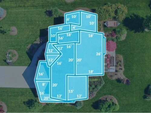

Small Business
Designed for startups and growing businesses
Medium Business
Built for business growth and flexibility
Enterprises
Designed for complex and large-scale business needs
4.1
Out of 5

Overall Rating
Based on
1 Verified Review
Rating Breakdown
87% Recommend this Product
Add Review
EagleView
Price On Request
Desktop
Mobile
Web based
On Premises
Windows
Mac OS

Zoho Survey
₹ 4992
Desktop
Mobile
Web based
On Premises
Windows
Mac OS

QS Plus Quantity surveying software
Price On Request
Desktop
Mobile
Web based
On Premises
Windows
Mac OS

Zoho Forms
Price On Request
Desktop
Mobile
Web based
On Premises
Windows
Mac OS
SogoCore
Price On Request
Desktop
Mobile
Web based
On Premises
Windows
Mac OS

Formsite
Price On Request
Desktop
Mobile
Web based
On Premises
Windows
Mac OS

Alchemer
Price On Request
Desktop
Mobile
Web based
On Premises
Windows
Mac OS

User Interviews
Price On Request
Desktop
Mobile
Web based
On Premises
Windows
Mac OS

Formly
Price On Request
Desktop
Mobile
Web based
On Premises
Windows
Mac OS

Microsoft Forms
Price On Request
Desktop
Mobile
Web based
On Premises
Windows
Mac OS

SurveySparrow
₹ 2397
Desktop
Mobile
Web based
On Premises
Windows
Mac OS
(2) Product(s) selected
Starting Price:
$25 /Month
Starting Price:
$55 /User/Month
Starting Price:
$49 /Session
Starting Price:
$19 /User/Month

Starting Price:
$19 /Month

Starting Price:
$19 /Month

Starting Price:
$10 /Month

Starting Price:
$83 /User/Month

Available
Price on Request

Starting Price:
$25 /Month

Starting Price:
$20 /Month
EagleView Customer Feedback Management Software is compatible with Windows operating systems.
EagleView Customer Feedback Management Software app is not available.
EagleView Customer Feedback Management Software supports Web-Based.
EagleView Customer Feedback Management Software is typically used in All Industries.
EagleView Customer Feedback Management Software demo is available for free with Techjockey.com
EagleView Customer Feedback Management Software offers a free trial. However, the premium plan with advanced features available at Techjockey .
For EagleView Customer Feedback Management Software installation, insert the given CD/USB flash storage in your system and open the Setup Wizard to get started.
EagleView Customer Feedback Management Software helps with Creation of as many surveys as desired,Clone the survey,Inimitable survey and Lightweight standalone setup. It's a complete solution for Graphical reports for better analysis,Provision to exports,Access Control and Customization & Branding.
EagleView price is avilable on request at techjockey.com.
EagleView property measurements are highly precise, with a stated accuracy rate of over 98 percent derived from high-resolution aerial imagery.
EagleView reports provide precise aerial measurements and property data used by contractors for bidding, insurers for claims adjusting, and solar professionals for system design.
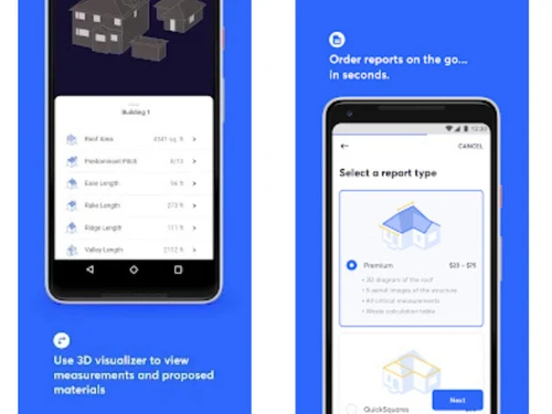
You can order reports through the EagleView platform, which provides access to high-resolution aerial imagery and property data via a flexible subscription service.
EagleView is used by roofing and construction contractors, insurance carriers and adjusters, solar installers, government agencies, and utility/energy companies for property measurement, claims, and asset management.
EagleView's aerial imagery offers up to 140 times higher resolution than standard satellite imagery, providing superior clarity and precision for property analysis.
EagleView Horizon is an AI-powered workspace that combines high-resolution aerial imagery, property intelligence, and third-party data to help teams identify and act on opportunities.
Yes, EagleView can generate interactive 3D property models from its imagery and measurements, allowing for clearer visualization and analysis of a structure.
Yes, EagleView is designed for seamless integration and can connect with your existing workflows, CRMs, or other third-party tools to activate its imagery and data.
20,000+ Software Listed
Best Price Guranteed
Free Expert Consultation
2M+ Happy Customers
Terms and Condtions

Users with registered businesses can purchase goods from merchants on the platform to satisfy their business needs. Users are not permitted to utilize any products acquired through the platform for resale, advertising, business, or further distribution.
For each purchase made, users will receive a Tax Invoice (or 'GST invoice') that includes specific details such as:
the GSTIN of the user associated with their registered business, and
the specified Entity Name for their business.
It should be noted that not all products are eligible for GST Invoice. Only the products displayed by participating sellers with the 'GST-based Invoice Available' callout on the product description page would qualify.
Certain goods and services are not eligible to get a GST Invoice, including items with VAS, i.e., Value Added Services (e.g., Total Mobile Protection/Assured Buyback) and those involving an exchange offer at the time of purchase.
Users must ensure the accuracy of the GSTIN, and business entity name provided for the GST Invoice. Requests for corrections into GST Invoice would not be accommodated by Techjockey.com or any Seller, and any issues arising from user-provided information are the sole responsibility of users.
Techjockey.com is not liable for the GST Invoice or any associated input tax credit. To efficiently claim an input tax credit, users should select the registered place of business address as per the GST authority's data and follow the provisions of the GST Act and rules.
To claim an input tax credit, the delivery and billing addresses must match. Furthermore, input tax credits will not be granted if the delivery address and GSTIN on the invoice are from different states. In case of incorrect GST details provided during the order placement, the order will be canceled automatically.