linkedin
ArcGIS Desktop Basic logo
play What is GIS?
ArcGis Desktop
ArcGis Desktop

ArcGIS Desktop Basic

Brand: Esri India Technologies Ltd

  • 4.3

  • 4 Ratings

ArcGIS Desktop Basic is the keystone product of the ArcGIS platform for geographic information system professionals. It enables you to create, examine, supervise, and share geo-data with your collaborators to make effective, informed, and intelligent decisions. ArcGIS Desktop Basic allows you to produce and manage unique maps equipped with data. ArcGIS Desktop Basic lets you analyze the existing ...

See More

Have you used ArcGIS Desktop Basic before?

Share your insights for better experience

Add a Review
Starting Price
₹63996

View plans

100% Genuine
Products
Best Price
Guaranteed
Safe & Secure
Payment
  • Description

  • Pricing

  • Features

  • Specification

  • Review

  • Compare

  • Alternatives

  • FAQ

Starting at ₹63,996

ArcGIS Desktop Basic Software Overview

What is ArcGIS Desktop Basic?

ArcGIS Desktop Basic is the keystone product of the ArcGIS platform for geographic information system professionals. It enables you to create, examine, supervise, and share geo-data with your collaborators to make effective, informed, and intelligent decisions. ArcGIS Desktop Basic allows you to produce and manage unique maps equipped with data.

ArcGIS Desktop Basic lets you analyze the existing data provided in the maps and enables you to add your observed data to enrich the maps with more information. ArcGIS Desktop Basic helps you conceptualize your area and makes you aware of all the nitty-gritty details that are overlooked while studying geography. It empowers you to make effective change and tangible value in your organization; ArcGIS Desktop Basic is an excellent tool for geo-data handling organizations.

Features of ArcGIS Desktop Basic

ArcGIS Desktop Basic is a great tool for geo-data and demography surveying organizations. Here are a few features listed below for your acquaintance:

  1. Map Creation: Produce maps of the areas you are managing and get interactive details of it. Add images and data to the maps from your observation and online sources to enrich them with more information. Get access to basic spatial examining tools for overlay, proximity, summary, and many more. With ArcGIS Desktop Basic at your helm, push your limits to reach higher levels of success.
  2. Multiuser Editing: ArcGIS Desktop Basic offers access to a complete GIS data editing system. Field teams can disperse into smaller units and simultaneously input data with no inconveniences. Users can add a historical snapshot of the observed data and automate quality control. From an organizational point of view, it helps you to oversee your workflows and job targets seamlessly.
  3. Advanced Analysis: Provide your organization with high-end GIS software that offers an advanced analysis of data. Put your field teams’ observation to test with the advanced GIS data analysis and modeling feature in ArcGIS Desktop Basic. Its cutting-edge cartography features help you to produce publication-quality data maps. You can store all your observations in the extensive database management of ArcGIS Desktop Basic.

Price of ArcGIS Desktop Basic

ArcGIS Desktop Basic is available in three different plans. They are

  1. ArcGIS Desktop Extensions Upgrade
  2. ArcGIS Desktop Basic Upgrade
  3. ArcGIS Desktop Advanced Upgrade

The prices of every plan vary on several factors such as size of operations, deployment type, etc.

Read more

ArcGIS Desktop Basic Pricing & Plans

ArcGIS Desktop Extensions Upgrade
Starting at ₹63996
    • Quantity

      Quantity
      Quantity

Key Features

  • Social Media Integration

  • Single Sign On

  • Third Party Integration

  • Wireless Network Support

  • Mobile Integration

  • Multilingual

  • Performance Management

  • Plugins and Widgets

  • GPS Tracking

ArcGIS Desktop Basic Upgrade
Starting at ₹81996
    • Quantity

      Quantity
      Quantity

Key Features

  • Social Media Integration

  • Single Sign On

  • Third Party Integration

  • Wireless Network Support

  • Mobile Integration

  • Multilingual

  • Performance Management

  • Plugins and Widgets

  • GPS Tracking

ArcGIS Desktop Advanced Upgrade
Starting at ₹355970
    • Quantity

      Quantity
      Quantity

Key Features

  • Social Media Integration

  • Single Sign On

  • Third Party Integration

  • Wireless Network Support

  • Mobile Integration

  • Multilingual

  • Performance Management

  • Plugins and Widgets

  • GPS Tracking

ArcGIS Desktop Basic Features

  • icon_check Social Media Integration
    Share your maps with your peers and targeted audience with ArcGIS Desktop Basic’s social media plugins.
  • icon_check Single Sign On
    ArcGIS Desktop Basic offers you with an air-tight security feature that gives you a valid individual single sign on feature.
  • icon_check Third Party Integration
     Integrate ArcGIS Desktop Basic with your day-to-day APIs. It is a great tool to add to your organization’s productivity
  • icon_check Wireless Network Support
    Getaway with all your cables and work with comprehensive GIS software that is entirely wireless. Your field team can achieve
  • icon_check Mobile Integration
     ArcGIS Desktop Basic is available as a mobile app for both android and iPhone users.
  • icon_check Multilingual
    ArcGIS Desktop Basic now supports multiple languages to work across the board efficiently and effectively.
  • icon_check Performance Management
     Check your users’ performances through the analysis tools embedded in ArcGIS Desktop Basic.
  • icon_check Plugins and Widgets
    ArcGIS Desktop Basic offers you plugins and widget tools to publish your maps at the social media sites without any annoyance.
  • icon_check GPS Tracking
    Track your daily work with the GPS tracker to keep a day-to-day update of the areas covered.
  • icon_check Integrated Mapping
    Provides a comprehensive environment for professional 2D and 3D map creation, data visualization, and cartography on any PC fast.
  • icon_check ArcMap Authoring Engine UI
    The core traditional GIS application for map authoring, enabling high-quality layout design with extensive symbol libraries now.
  • icon_check Data Management
    Organizes and manages geographic information, including shapefiles and file geodatabases, within an intuitive folder structure.
  • icon_check Spatial Analysis Toolset Pro
    Includes hundreds of essential tools for buffer analysis, clipping, and overlay operations to solve spatial problems daily now.
  • icon_check Online Connectivity
    Syncs your desktop projects with the cloud to browse thousands of global basemaps and datasets for your professional maps now.
  • icon_check Raster Visualization
    Displays and manages various image formats, allowing you to use satellite imagery and aerial photos as high-quality basemaps now.
  • icon_check Custom Symbology Designer
    Offers a vast library of industry-standard symbols and colors to create clear, professional, and accurate cartographic products.
ArcGIS Desktop Basic Demo Video play icon

Get ArcGIS Desktop Basic Demo

Watch the demo video to explore key features, real workflows, and how the software fits your business needs.

Understand
Key Features
Personal
Demo Insights
Interactive
Demo Support

ArcGIS Desktop Basic Specification

Supported Platforms
Windows Windows
Devices
Desktop Desktop Tablet Tablet
Deployment
Perpetual Perpetual
Suitable For
All Industries
Business Specific
All Businesses
Business Size
Individual Small Business Startups Medium Business Enterprises SMBs SMEs
Customer Support
Phone Email Live Chat Communities Forums
Language
English
Integration
API Integration
Training Resources
In Person Live Online Webinars Documentation Videos
Compliance Regulation
HIPAA

Explore the Best Alternative Solutions Similar to Your Business Size and Needs

ArcGIS Desktop Basic Review

4.3

Out of 5

img

Overall Rating

Based on
4 Verified Ratings

Rating Breakdown

  • Features 4
  • Value for Money 4.5
  • Ease of Use 4.2
  • Customer Support 4.7

87% Recommend this Product

Add Review

Be the First to Review

This product has no reviews yet. Be the first to leave your feedback.

Add Review

Compare ArcGIS Desktop Basic With other GIS Software

Products
Ratings
Pricing
Device Supported
Deployment
Supported Platforms
  • img

    ArcGIS Desktop Basic

  • 4.3

  • Price On Request

  • Desktop

    Mobile

  • Web based

    On Premises

  • Windows

    Mac OS

  • img

    ArcGIS Enterprise

  • 5

  • Price On Request

  • Desktop

    Mobile

  • Web based

    On Premises

  • Windows

    Mac OS

  • img

    ArcGIS Online

  • 4.2

  • Price On Request

  • Desktop

    Mobile

  • Web based

    On Premises

  • Windows

    Mac OS

  • img

    ArcGIS Pro

  • 4.2

  • Price On Request

  • Desktop

    Mobile

  • Web based

    On Premises

  • Windows

    Mac OS

  • img

    ENVI GIS Software

  • 4.1

  • Price On Request

  • Desktop

    Mobile

  • Web based

    On Premises

  • Windows

    Mac OS

  • img

    Nearmap

  • 4.0

  • Price On Request

  • Desktop

    Mobile

  • Web based

    On Premises

  • Windows

    Mac OS

  • img

    Geosoft Target

  • 4.6

  • Price On Request

  • Desktop

    Mobile

  • Web based

    On Premises

  • Windows

    Mac OS

  • img

    Mango GIS Software

  • 4.2

  • Price On Request

  • Desktop

    Mobile

  • Web based

    On Premises

  • Windows

    Mac OS

  • img

    BatchGeo

  • 4.1

  • Price On Request

  • Desktop

    Mobile

  • Web based

    On Premises

  • Windows

    Mac OS

(0) Product(s) selected

ArcGIS Desktop Basic Alternatives

See All ArcGIS Desktop Basic Alternatives

Available

Price on Request

Starting Price:

$99

QGIS

4.1

Available

Price on Request

Is ArcMap the same as ArcGIS?

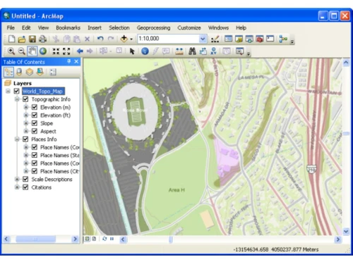
ArcGIS for Desktop consists of several integrated applications, including ArcMap, ArcCatalog, ArcToolbox, ArcScene, ArcGlobe, and ArcGIS Pro. ... ArcMap is the application used to view, edit and query geospatial data, and create maps.

How do you use GIS?

GIS software lets you produce maps and other graphic displays of geographic information for analysis and presentation. With these capabilities a GIS is a valuable tool to visualize spatial data or to build decision support systems for use in your organization.

What are the system requirements of ArcGIS Desktop Basic?

Here are minimum hardware requirements for ArcGIS Desktop Basic: 1. Processor: 2.2 GHz, Hyper-threading or multi-core recommended 2. Platform: x86 or x64 with SSE2 extensions 3. RAM: 2GB Minimum 4. Display: 24-bit color depth 5. Screen Resolution: 1024*768 (96 dpi) 6. Disk Space: 1.6 GB ArcGIS Engine creates cache files when used; additional disk space may be required. 7. Video/Graphics Adapter: 64 MB RAM minimum; 256 MB RAM or higher recommended. NVIDIA, ATI, and Intel chipsets supported. 24-bit capable graphics accelerator OpenGL version 2.0 runtime minimum is required, and Shader Model 3.0 or higher is recommended.

Who are the typical users of ArcGIS Desktop Basic?

ArcGIS Desktop Basic is predominantly used by meteorological department, surveying agencies, and organizations that involve heavily in demography studies.

Is ArcGIS Desktop Basic available on mobile phone?

ArcGIS Desktop Basic is available for both Android and iPhone users. The app can be found on the app store of your respective mobile phones.

Is ArcGIS Desktop Basic available for demo?

Yes, ArcGIS Desktop Basic is available for demo. Please request a call and our sales team will get in touch with you as soon as possible.

Is ArcGIS Desktop Basic a cloud-based or on-premise?

ArcGIS Desktop Basic is an on-premise software that works completely online as well as offline. It saves data in your system, shares the necessary data with your collaborators automatically.

20,000+ Software Listed

Best Price Guranteed

Free Expert Consultation

2M+ Happy Customers

Terms and Condtions

close

Users with registered businesses can purchase goods from merchants on the platform to satisfy their business needs. Users are not permitted to utilize any products acquired through the platform for resale, advertising, business, or further distribution.

For each purchase made, users will receive a Tax Invoice (or 'GST invoice') that includes specific details such as:

  • the GSTIN of the user associated with their registered business, and

  • the specified Entity Name for their business.

It should be noted that not all products are eligible for GST Invoice. Only the products displayed by participating sellers with the 'GST-based Invoice Available' callout on the product description page would qualify.

Certain goods and services are not eligible to get a GST Invoice, including items with VAS, i.e., Value Added Services (e.g., Total Mobile Protection/Assured Buyback) and those involving an exchange offer at the time of purchase.

Users must ensure the accuracy of the GSTIN, and business entity name provided for the GST Invoice. Requests for corrections into GST Invoice would not be accommodated by Techjockey.com or any Seller, and any issues arising from user-provided information are the sole responsibility of users.

Techjockey.com is not liable for the GST Invoice or any associated input tax credit. To efficiently claim an input tax credit, users should select the registered place of business address as per the GST authority's data and follow the provisions of the GST Act and rules.

To claim an input tax credit, the delivery and billing addresses must match. Furthermore, input tax credits will not be granted if the delivery address and GSTIN on the invoice are from different states. In case of incorrect GST details provided during the order placement, the order will be canceled automatically.